
This is a new service – your feedback will help us to improve it.

Newcastle City Council

Tree preservation zone

There is a problem

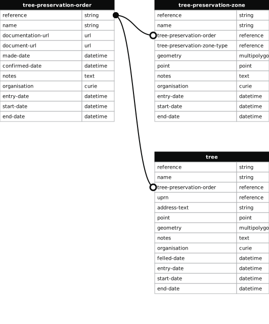
  • 1000 entries with tree-preservation-order field must match the reference field in the tree preservation order dataset

High Gosforth Park

reference
1995/017.W19
name
High Gosforth Park
tree-preservation-order

undefined

1995/017
tree-preservation-zone-type
woodland
geometry
MULTIPOLYGON (((-1.589007 55.027701,-1.588794 55.027843,-1.588971 55.028095,-1.589099 55.028270,-1.589188 55.028388,-1.589340 55.028601,-1.589432 55.028727,-1.589466 55.028777,-1.589561 55.028909,-1.589676 55.029146,-1.589854 55.029422,-1.589965 55.029638,-1.590143 55.029946,-1.590190 55.030035,-1.590329 55.030211,-1.590494 55.030438,-1.590518 55.030484,-1.590567 55.030564,-1.590795 55.030958,-1.590878 55.031187,-1.590931 55.031328,-1.590961 55.031417,-1.591229 55.031711,-1.591435 55.031940,-1.592214 55.032431,-1.592805 55.032816,-1.592820 55.032823,-1.592867 55.032839,-1.592898 55.032845,-1.592990 55.032858,-1.593097 55.032841,-1.593129 55.032838,-1.593151 55.032838,-1.593325 55.032811,-1.593502 55.032777,-1.593737 55.032727,-1.594024 55.032669,-1.594161 55.032644,-1.594319 55.032620,-1.594508 55.032599,-1.594603 55.032590,-1.594681 55.032585,-1.595019 55.032572,-1.595114 55.032570,-1.595160 55.032567,-1.595210 55.032567,-1.595972 55.032612,-1.596297 55.032633,-1.596604 55.032656,-1.596783 55.032671,-1.597131 55.032704,-1.597324 55.032728,-1.597446 55.032745,-1.597543 55.032763,-1.597826 55.032822,-1.597834 55.032806,-1.597908 55.032577,-1.597894 55.032576,-1.597927 55.032446,-1.598074 55.031828,-1.598106 55.031683,-1.598366 55.030924,-1.598132 55.030909,-1.598059 55.030897,-1.598002 55.030879,-1.597950 55.030851,-1.597919 55.030806,-1.597875 55.030730,-1.597852 55.030637,-1.597860 55.030465,-1.597865 55.030455,-1.597889 55.030440,-1.597915 55.030435,-1.597982 55.030442,-1.598037 55.030454,-1.598088 55.030471,-1.598123 55.030507,-1.598138 55.030517,-1.598183 55.030528,-1.598232 55.030531,-1.598289 55.030527,-1.598335 55.030515,-1.598370 55.030498,-1.598392 55.030469,-1.598406 55.030445,-1.598410 55.030416,-1.598407 55.030383,-1.598389 55.030351,-1.598299 55.030301,-1.594496 55.029272,-1.592250 55.028661,-1.591123 55.028358,-1.591086 55.028350,-1.590790 55.028272,-1.589849 55.028018,-1.589744 55.028028,-1.589369 55.027933,-1.589350 55.027911,-1.589327 55.027889,-1.589271 55.027857,-1.589204 55.027831,-1.589144 55.027815,-1.589132 55.027810,-1.589131 55.027803,-1.589148 55.027748,-1.589149 55.027735,-1.589146 55.027725,-1.589136 55.027712,-1.589107 55.027697,-1.589081 55.027691,-1.589052 55.027689,-1.589026 55.027694,-1.589007 55.027701)))
point
POINT (-1.593801 55.030663)
notes
These data are update live via a feed to NCC's Tree Managament System, EzyTreev
entry-date
2022-07-01
start-date
1995-01-01
end-date

How to fix this issue

Your data is missing a tree-preservation-order.

The Tree preservation zone guidance explains how to fix the issue:

tree-preservation-order

The reference for the tree preservation order that covers this zone.
How to improve Newcastle City Council’s data

  1. Fix the errors indicated
  2. Use the check service to make sure the data meets the standard
  3. Publish the updated data on the endpoint URL